Veterans Park

Veterans Park

Good location to get on the Greenbelt and walk to the PA Farm Show or just do an out and back on the Greenbelt.  There is plenty of room to have a picnic or potluck. 

General Directions:from Rt 81 take Progress Avenue South
Right onto Elmerton
Then Left into the Park.
Park close to Greenbelt entrance

1955 Elmerton AvenueHarrisburg, PA  17109

Link to their website

Link to map


East Hanover Nature Park

East Hanover Nature Park

The main trail loop is about 0.9 miles starting at the parking lot. There are multiple spur trails that can lengthen or shorten your hike. The trail is rated easy and only has about 80ft of elevation gain.

Directions:From 81 North take exit 77 toward Grantville / Hershey. From the ramp, bear to the right toward Sheetz.Turn left at the first traffic light onto Johnstown roadAfter about 2 miles turn right onto N. Crawford road . The sign for the park will come up quickly on left side

328 N Crawford RdGrantville, PA  17028

Link to their website


Detweiler Park

Detweiler Park

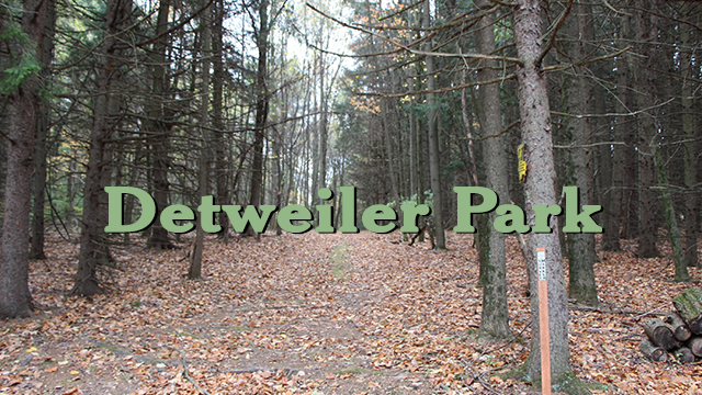
Detweiler Park has more than 7 miles of trails winding through varied habitats. Gardens, fields, meadows, evergreen plantations, and mature deciduous forests are some of the ecosystems in this biologically diverse park. Deer are seen frequently as well as a wide variety of birds including turkeys, hawks, woodpeckers, and bluebirds. Trails are open daily from dawn to dusk.

No hunting or trapping is allowed in this park so it is a good choice for hunting season.  The Airstip Loop and David’s Field Loop are flat so very good for winter walking or snowshoeing.


General Directions:
from 322 West
take Dauphin/Halifax rt 225 N exit
in 2 miles you will see 325 east/Clarks Valley Road to your right and 3Bs Ice Cream on your left
the entrance to Detweiler Park is just past this intersection and almost directly across the street from 3Bs
It is easy to miss the sign so slow down and keep you eye out for it.
1451 Peters Mountain Road
Dauphin, PA  17018

Link to their website


https://maps.app.goo.gl/G1Qg4Fe5cgfw7AMY6

You could picnic here in the summer months and 3Bs is another good choice for dinner.

AT Parking Lot on 325

AT Parking Lot on 325

There are several trail options available from this parking lot.  Heading South on the AT, you can climb back up Peter’s Mountain to the View.  You can walk the lower road in and out for an easy, flat walk in the woods.  You could take the AT North with a steep climb and do an out and back for any mileage.  The AT eventually connects with the Horseshoe Trail terminus.  Or you can do a 5.1 mile hike which is very strenuous with 1,200 feet elevation to the fire tower. It will take over 2 hours to finish.  This trail uses several connecting trails to form a loop.

The lot has plenty of parking, this area is heavily traveled when the thru-hikers come through in the Summer.

General Directions:

From Rt. 322 to Dauphin.  In Dauphin take Rt. 225 toward Halifax.  Before going up Peter’s Mountain turn RIGHT on Rt. 325.  Go 10 miles to the A.T.  parking lot  on the RIGHT.  Park in the bottom lot along the creek.

Appalachian National Scenic Trail
Halifax, PA 17032

Link to map

There is plenty of room to have a potluck in the parking lot afterwards or head back to the intersection of Routes 325 and 225 to eat at 3Bs during the summer months.

Opossum Lake

Opossum Lake

Around Opossum Lake is a 4 mile trail marked with blue dots. It is a mainly flat trail.  Good for any season.

General Directions:
From Harrisburg area
Take Wertzville Rd. (944) West to McClures Gap Rd.  Be careful, as there are a few zigs & zags & dog leg turns
Turn left onto McClures Gap Rd
Turn right onto Easy Rd
Turn right onto Opossum Lake Rd
go about 1 mile & turn left to the “lake”
park at the pavilion which has a nice outhouse.

From 641
Turn Right onto McClures Gap Rd  2.9 mi
Turn left onto Campground Rd  .4 mi
Conntinue onto Opossum Lake Rd. 1 mi
Turn left to the “lake”

From 81
Take exit 44 onto 465 N.  3.8 miles Turn leftonto PA-641 W/E Main St/Newville Rd
Take the 1st right onto Meadowbrook Rd
Turn left onto Conodoguinet Ave
Continue onto Meadowbrook Rd
Turn right onto Willow Grove Rd
Slight left onto Meadowbrook Rd
Turn left onto Campground Rd
Continue onto Opossum Lake Rd
Turn left into the park.

205 Opossum Lake Road
Carlisle, PA  17015

Link to their website

Link to map

Opossum Lake Trail Map

Picnic pavillion at lake available for potluck afterwards

LeTort Spring Run Trail

LeTort Spring Run Trail

LeTort Spring Run Nature Trail is a 2.5-mile out-and-back trail that runs alongside LeTort Spring Run through a mixture of deciduous trees and lowland marshes (except for a short portion of the trail that travels along South Bedford Street.) The trail is an easy hike on relatively flat 8 to 10-foot-wideall weather stone surface. There are two entrances to the trail and both are easily accessible. The first is in LeTort Park, the second is at Bonny Brook Road, and the third is at South Spring Garden Street.

General Directions to Park at the Giant at Spring Garden Street:

Take I-81 to Exit #47b, Hanover Street – Route 34 North
Go to the 4th stop light (aprox. .8 miles) and turn right on Pomfrett Street.
At the stop light turn right on S. Spring Garden Street
The Carlisle Markeplace Shopping Center is 1 block up on the LEFT
Park at the far end of the lot in front of the Wine & Spirit shop close to Spring Garden Street.

Carlisle Marketplace Shopping Center
255 S Spring Garden Street
Carlisle, PA  17013


Map of the trail

Good after hiking dinner location nearby is:

Market Cross Pub and Brewery