Cove Mountain Preserve

Cove Mountain Preserve

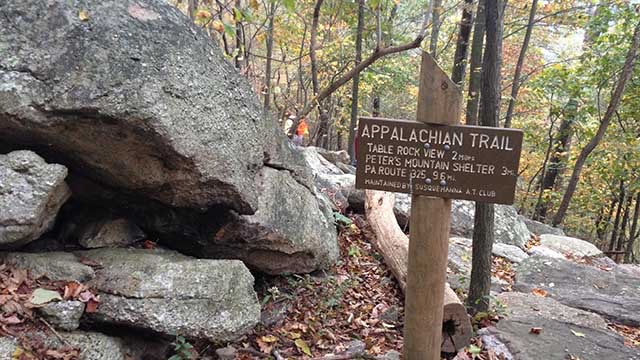
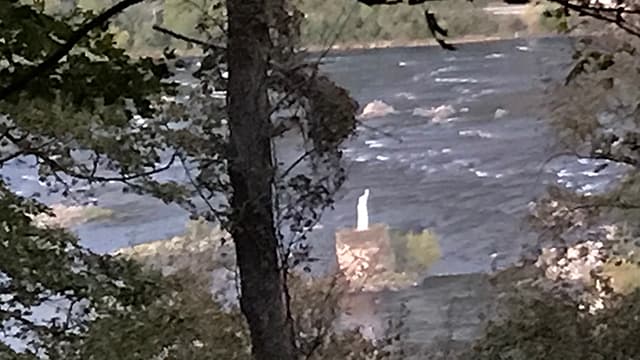
Cove Mountain Preserve is the town of Marysville and very easy to get to.  There is a wide variety of trails that you can loop together to get a short or long hike in.  The upper trails offer excellent views of the Susquehanna River and The Statue of Liberty and The Rockville Bridge. This locations is great for Paw Paw picking in the Fall.

Plenty of room in the parking lot and picnic tables for a potluck.

Trail Information:

Purple Trail (1.9 miles)
Yellow Trail (0.5 miles)
Pink Trail (1.3 miles)
Orange Trail (4.6 miles)
Green Trail (0.5 miles)
Blue Trail (1.1 miles) 


General Directions:

NOTE: Parking and a trailhead for Hamer Woodlands at Cove Mountain is located at the upper gravel parking lot for the Wesley United Methodist Church of Marysville (450 Sylvan St, Marysville, PA 17053).

Traveling from the PA Turnpike I-76:

  • Take exit 242 (York – Baltimore, Harrisburg) and merge onto I-83 North.
  • Take exit 41B for Lemoyne and turn left onto Lowther Street. Turn left onto South 3rd Street then turn right onto Market Street.
  • Turn left onto South Front Street and continue onto US-11 North / US-15 North to Marysville.
  • In Marysville, turn left onto Spruce Street then a quick right onto Linden Avenue. Turn Left on Sylvan Street and follow up the hill till you come to the upper gravel parking lot for the Wesley United Methodist Church.

Traveling from the south:

  • From Interstate 81 take Exit 65 for US-15 N/US-11 N toward Marysville.
  • Turn left onto Spruce St. Turn right onto Linden Ave. Turn left onto Sylvan Street.

Traveling from the north:

  • From US-22 E/USS-322 E take exit onto US-11 S/US-15 S toward Camp Hill.
  • Turn right onto Spruce St. Turn right onto Linden Ave. Turn left onto Sylvan St.

Victoria Trail

Victoria Trail

Victoria Trail is moderately challenging due to the relatively steep climb up Peter’s Mountain.  From 325 in Dauphin you can climb up Peter’s Mountain and connect with the Appalachian Trail.  You can either turn left on the AT and drop down into Joseph E. Ibberson Conservation Area shortly to the right.  This loop can be as long as you want because there are many trails in the Conservation Area to explore.  A popular route is to follow the Victoria Trail until you reach The Whitetail Trail and turn right onto it.  There you can climb back up the mountain and cross back over the AT and down the other side and eventually reconnect with the Victoria and return to the parking Lot. This loop would be approximately 5 miles.  A shorter option would be to take the Appalachian Trail to the right, turn right onto the Whitetail Trail which will reconnect with the Victoria Trail.  This loop would be approximately 3 miles.

3Bs is right at the corner of 225 and 325 and a good place to have dinner.  There are picnic tables and they serve hot and cold food there in the warmer months.  Confirm they will be open before making plans to eat there after a hike.

General Directions:
from 322 West
take Dauphin/Halifax rt 225 N exit
in 2 miles take right onto 325 east/Clarks Valley Road
in 5 miles there is a gravel lot on left. 

Note:  This parking lot has a history of targeted vandalism.  Please do not leave any visible valuable belongings in your vehicle.  They will break your window and steal.

Mount Holly Marsh Preserve

Mount Holly Marsh Preserve

Mount Holly Marsh has 7 miles of trails ranging from easy to challenging.  There is hunting permitted in the area so wear orange and be mindful of hunting seasons.  You can fish in Mountain Creek.  The trail can be a bit muddy at time during the wet season and also along the creek.

Plenty of room in the parking lot to have a potluck but it can be buggy in the summer.
Cassell’s Grille is close by in Mount Holly Springs and a good option for dinner.
Link to their website

Trail Information:

Marsh Loop Trail is approximately 2.2 miles (out and back) and is marked with blue blazes. The Marsh Loop begins at the parking area and is the starting point for the park’s trail network. Follow this trail to connect with the Spring, Creek, Briar and Ridge Trails. For an easy hike, try this trail.

Lamberton Trail is about 1 mile (out and back) of steep, rocky terrain marked with a white blaze. This trail is best left to more experienced hikers. The Lamberton Trail begins near the parking area.

Spring Trail is about 0.5* mile long (one way) and marked with green blazes. Take this easy path to view the bountiful, bubbling spring.

Creek Trail is about 1.4* miles (loop) in length and is indicated with red blazes. For an easy to moderate hike, try this scenic trail.

Briar Trail is about 1.2* miles (one way) and is marked with orange blazes. Hikers who want a moderate challenge should try this trail.

Ridge Trail is about 2.2* miles (out and back) of moderate to steep, wooded terrain marked with yellow blazes. Hikers who want more of a challenge should take this trail.


General Directions:
From Route 81 exit 47A Route 34 South

Go through Mt Holly Springs
Shortly after leaving town, the trail head road is just after the old Log Cabin Restaurant on right.
AT at Sherwood

AT at Sherwood

The Appalachian Trail crosses Sherwood Road here.  If you take the trail North, you head towards Wertzville Road and eventually climb up the mountain to the Cumberland Valley Overlook.  If you head South on the trail you will be heading back to Scott Farm and eventually cross over the pedestrian bridge on the Carlisle Pike

General Directions:
From 81, take the Wertzville Road exit, go west on Wertzville Road (Rt 944)
Turn left onto Deer Lane
Turn right onto Sherwood Dr. (closest house to lot is 217 Sherwood Dr if you want to plug that into maps)

There is a lot of room to park here although it is a popular spot so parking may fill up on weekends. Wednesday nights shouldn’t be too bad.  There is room to have a potluck in the parking lot afterwards.

Appalachian Trail – Sherwood Road
Carlisle, PA 17015

GPS Coordinates: 40.274098, -77.099392

Link to driving map


Wednesday Nights

at 6:00 PM


Contact Us

© 2023 Unigraphics Communications

AT at Sheet Iron Roof Road

AT at Sheet Iron Roof Road

The Appalachian Trail North heads towards Whiskey Springs Road and Rocky Ridge which is a nice Rock Maze.  The trail stays fairly flat for approximately 2 miles then climbs around 750 to the top of the mountain. Heading South you will enter into Michaux State Forest towards Pine Grove Furnace.  The trail is fairly flat in this direction with only 200 feet or so elevation gain to Route 34.  There are a few options for dinner afterwards in Mount Holly Springs.  At the top of the mountain, heading North, there is a nice flat spot with a view to have dinner as well.

General Directions:  From Mount Holly Springs on Route 34, stay on 34 South through town.  Just on the other side of town, turn left onto 94 South at the Y.  Follow 94 for 1.3 miles and turn left onto Sheet Iron Roof Road.  The parking area will be .3 miles on your right.

There is a pull-off with room to park approximately 5 vehicles.  You may be able to fit more along the road.

Appalachian Trail – Sheet Iron Roof Road
Gardners, PA 17324

GPS Coordinates: 40.093020, -77.164440

Link to driving map


Wednesday Nights

at 6:00 PM


Contact Us

© 2023 Unigraphics Communications