AT at Sheet Iron Roof Road

AT at Sheet Iron Roof Road

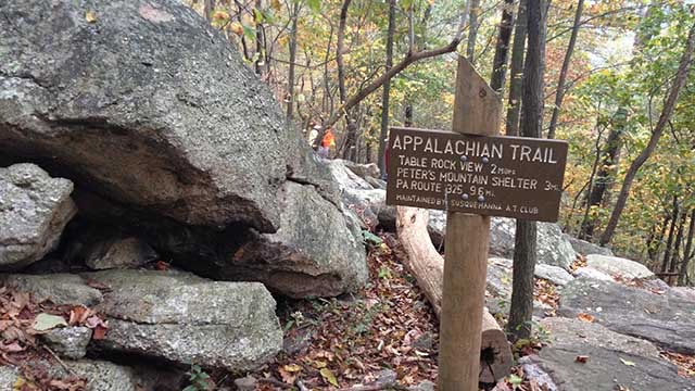
The Appalachian Trail North heads towards Whiskey Springs Road and Rocky Ridge which is a nice Rock Maze.  The trail stays fairly flat for approximately 2 miles then climbs around 750 to the top of the mountain. Heading South you will enter into Michaux State Forest towards Pine Grove Furnace.  The trail is fairly flat in this direction with only 200 feet or so elevation gain to Route 34.  There are a few options for dinner afterwards in Mount Holly Springs.  At the top of the mountain, heading North, there is a nice flat spot with a view to have dinner as well.

General Directions:  From Mount Holly Springs on Route 34, stay on 34 South through town.  Just on the other side of town, turn left onto 94 South at the Y.  Follow 94 for 1.3 miles and turn left onto Sheet Iron Roof Road.  The parking area will be .3 miles on your right.

There is a pull-off with room to park approximately 5 vehicles.  You may be able to fit more along the road.

Appalachian Trail – Sheet Iron Roof Road
Gardners, PA 17324

GPS Coordinates: 40.093020, -77.164440

Link to driving map


Wednesday Nights

at 6:00 PM


Contact Us

© 2023 Unigraphics Communications

Wildwood Park

Wildwood Park

Wildwood Park is a good location for winter hikes and basically anytime of year.  The loop around the park is 3.1 miles with a few trails trails you can do to add miles.  There are plenty of restaurants on Linglestown Road to eat afterwards.

General Directions to Main Lot:
From 81 take Front Street North.
Turn Right on Linglestown Rd
At the First Light take Right onto Industrial Road
Just before you go under the 81 overpass, you will see the main entrance to the park. There is parking along the road and also a large lot near the Olewine Nature Center.

General Directions to North Lot:
From 81 take Front Street North.
Turn Right on Linglestown Rd
At the First Light take Right onto Industrial Road
Parking lot is on Left, first lot of Wildwood

Wildwood Main Lot:
100 Wildwood Way
Harrisburg, PA 17110
Link to map

Wildwood North Lot
2337 Industrial Road
Harrisburg, PA. 17110
Link to map

State Game Lands 305

State Game Lands 305

Plenty of trails go through State Game Lands 305.  You can do the outer loop and end up with a little over 5 miles or take a shorter route and do as little as 2 miles.  There are maps available on the State Game Lands website but have limited trail details.  The best trail information is available on the AllTrails app.  Several maps are available below for download.  There are several options to park along the State Game Lands road but the lot listed here is the largest and can fit the most vehicles.  This lot has plenty of room for a tailgate afterwards.  The closest town for restaurants is Boiling Springs but Dillsburg is not too far as well. 

General Directions:
The best thing to do is use the GPS coordinates below but basic directions are as follows:
From Boiling Springs, take either Race Street to Mountain Road or Petersburg Road to Mountain Road follow Mountain Road until you see the sign for Diakon Youth Wilderness Camp.  Turn onto gravel road and follow this for approx .8 mile to large parking lot on right.

State Game Lands 305:

Link to driving map


Maps to Download:


Hocker Park

Hocker Park

At Hocker park you can do 3.4 mile lollipop hike into Boyd’s.  There is a steep descent and ascent of approximately 325 feet.  Except for those two areas, this trail is fairly level and a good choice for anytime of the year.  You can add mileage by doing loops in Boyd’s Big Tree.  The distance to Boyd’s is approximately 1 mile each way.  To do the outer loop at Boyd’s you would have approximately 6.5 miles including the out and back. 

Plenty of parking available.  There are two picnic tables and a grill available in the parking lot.  A lot of food options are also available on Linglestown Road.

General Directions:

Hocker Park can be accessed from Route 443, Linglestown Road or I81 

From I 81 Linglestown Road Exit:
From Exit 72B toward Linglestown:
Merge N. Mountain Road 0.4 mile
At circle , take 3rd exit onto Linglestown Road 0.3 mi
At circle take 1st exit onto Blue Mountain Parkway 0.2 mi
LEFT to stay on Blue Mountain Parkway 0.7 mile
LEFT to stay on Blue Mountain Parkway 1.1 mile
Hocker Park at top of hill on left side 

From Front Street :
Head North on Front Street and turn right onto Linglestown Road
Drive approximately 9.8 miles and turn left onto Parkway West
Drive approximately 2 miles and turn left onto Blue Mountain Parkway
Hocker park will be on your left in 3/10 of a mile 

From 443:
From Front Street drive approximately 6.3 miles and turn right onto Blue Mountain Parkway
Stay on Blue Mountain Parkway for approximately 1.7 miles
Hocker Park will be on your right at the top of the hill  

Hocker Park:
2280 Blue Mountain Parkway
Harrisburg, PA 17109
Link to driving map
Link to website


Wednesday Nights

at 6:00 PM


Contact Us

© 2023 Unigraphics Communications

Hotel Hershey

Hotel Hershey

The Hotel Hershey has trails around and behind the hotel.  They are mainly flat with a few small hills to climb.  You can get up to 4 miles in and around combining walks and paths.  Best place to park is in front of the hotel.  

Plenty of options to eat afterwards either at the hotel or in the area.

General Directions:
FROM I-83 Follow 83 to 322 East and get off at the Hersheypark exit Route 39 onto Hersheypark Drive.  When you see the park on your right, look for Hotel Road on your left and turn left.  The Hotel entrance will be on your left approx 4/10 mile and directly across from the Hershey Gardens
FROM I-81 The best option here is to take I-81 to Exit 77 Manada Hill and 39 East.  Take 39 East towards Hershey until you come to Hersheypark Drive in approx. 7 miles and turn left.  Take the very next left onto Hotel Road.  The Hotel entrance will be on your left approx 4/10 mile and directly across from the Hershey Gardens.

100 Hotel Road
Hershey, PA 17033

Link to their website

Link to map