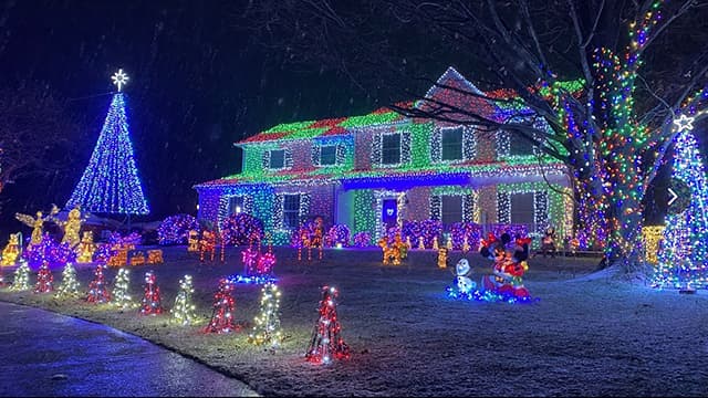
Linglestown Lights

Linglestown Lights

Linglestown Light is a perfect thing to do in the month of December for an evening stroll.  You can do as little or as much as you like and also enjoy festive Christmas lights along the way. 

Parking available at several places:

You could get permission to park at the Lingestown United Methodist Church in the back lot off of Blackberry Lane.
You can also park at the website suggested spot: 5780 Stillwell Court, Linglestown, PA 17112

Plenty of food option nearby for dinner afterwards

More information about Linglestown Lights can be found on their website.

Parking in the back lot of Linglestown United Methodist Church off of Blackberry Lane.

5780 Stillwell Court
Linglestown, PA. 17112

AT Parking Lot on Route 34

AT Parking Lot on Route 34

The Appalachian Trail can be accessed from this parking lot just outside of Mount Holly Springs.  The trail is relatively flat in both directions for a while and makes for a fairly easy in and out hike.  
Directions to the AT parking lot on Route 34:

From Mt. Holly Springs take 34 South over RR tracks bear right at the Filter Plant staying on Route 34 go 2 miles and the AT parking lot will be on your right, just before Green Mountain. Rd. The lot is across from the TLV Garage. If you pass the Green Mountain General Store, you went too far. You can get there also from Rt.15 to York Springs/ Idaville area back roads to Rt. 34
Nearby restaurants include:
Cassell’s Grille
5 W Pine Street
Mt Holly Springs, PA
Link to their website

Big Hill Ciderworks
338 Georgetown Road
Gardners, PA 17324
Link to their website

4679-4683 Carlisle Road
Gardners, PA 17324

Mount Holly Marsh Preserve

Mount Holly Marsh Preserve

Mount Holly Marsh has 7 miles of trails ranging from easy to challenging.  There is hunting permitted in the area so wear orange and be mindful of hunting seasons.  You can fish in Mountain Creek.  The trail can be a bit muddy at time during the wet season and also along the creek.

Plenty of room in the parking lot to have a potluck but it can be buggy in the summer.
Cassell’s Grille is close by in Mount Holly Springs and a good option for dinner.
Link to their website

Trail Information:

Marsh Loop Trail is approximately 2.2 miles (out and back) and is marked with blue blazes. The Marsh Loop begins at the parking area and is the starting point for the park’s trail network. Follow this trail to connect with the Spring, Creek, Briar and Ridge Trails. For an easy hike, try this trail.

Lamberton Trail is about 1 mile (out and back) of steep, rocky terrain marked with a white blaze. This trail is best left to more experienced hikers. The Lamberton Trail begins near the parking area.

Spring Trail is about 0.5* mile long (one way) and marked with green blazes. Take this easy path to view the bountiful, bubbling spring.

Creek Trail is about 1.4* miles (loop) in length and is indicated with red blazes. For an easy to moderate hike, try this scenic trail.

Briar Trail is about 1.2* miles (one way) and is marked with orange blazes. Hikers who want a moderate challenge should try this trail.

Ridge Trail is about 2.2* miles (out and back) of moderate to steep, wooded terrain marked with yellow blazes. Hikers who want more of a challenge should take this trail.


General Directions:
From Route 81 exit 47A Route 34 South

Go through Mt Holly Springs
Shortly after leaving town, the trail head road is just after the old Log Cabin Restaurant on right.
AT at Sherwood

AT at Sherwood

The Appalachian Trail crosses Sherwood Road here.  If you take the trail North, you head towards Wertzville Road and eventually climb up the mountain to the Cumberland Valley Overlook.  If you head South on the trail you will be heading back to Scott Farm and eventually cross over the pedestrian bridge on the Carlisle Pike

General Directions:
From 81, take the Wertzville Road exit, go west on Wertzville Road (Rt 944)
Turn left onto Deer Lane
Turn right onto Sherwood Dr. (closest house to lot is 217 Sherwood Dr if you want to plug that into maps)

There is a lot of room to park here although it is a popular spot so parking may fill up on weekends. Wednesday nights shouldn’t be too bad.  There is room to have a potluck in the parking lot afterwards.

Appalachian Trail – Sherwood Road
Carlisle, PA 17015

GPS Coordinates: 40.274098, -77.099392

Link to driving map


Wednesday Nights

at 6:00 PM


Contact Us

© 2023 Unigraphics Communications

Wildwood Park

Wildwood Park

Wildwood Park is a good location for winter hikes and basically anytime of year.  The loop around the park is 3.1 miles with a few trails trails you can do to add miles.  There are plenty of restaurants on Linglestown Road to eat afterwards.

General Directions to Main Lot:
From 81 take Front Street North.
Turn Right on Linglestown Rd
At the First Light take Right onto Industrial Road
Just before you go under the 81 overpass, you will see the main entrance to the park. There is parking along the road and also a large lot near the Olewine Nature Center.

General Directions to North Lot:
From 81 take Front Street North.
Turn Right on Linglestown Rd
At the First Light take Right onto Industrial Road
Parking lot is on Left, first lot of Wildwood

Wildwood Main Lot:
100 Wildwood Way
Harrisburg, PA 17110
Link to map

Wildwood North Lot
2337 Industrial Road
Harrisburg, PA. 17110
Link to map

State Game Lands 305

State Game Lands 305

Plenty of trails go through State Game Lands 305.  You can do the outer loop and end up with a little over 5 miles or take a shorter route and do as little as 2 miles.  There are maps available on the State Game Lands website but have limited trail details.  The best trail information is available on the AllTrails app.  Several maps are available below for download.  There are several options to park along the State Game Lands road but the lot listed here is the largest and can fit the most vehicles.  This lot has plenty of room for a tailgate afterwards.  The closest town for restaurants is Boiling Springs but Dillsburg is not too far as well. 

General Directions:
The best thing to do is use the GPS coordinates below but basic directions are as follows:
From Boiling Springs, take either Race Street to Mountain Road or Petersburg Road to Mountain Road follow Mountain Road until you see the sign for Diakon Youth Wilderness Camp.  Turn onto gravel road and follow this for approx .8 mile to large parking lot on right.

State Game Lands 305:

Link to driving map


Maps to Download: